Kings Canyon National Park - Guide to California's Kings Canyon National Park
Of the 75 or so sequoia groves in the world, Sequoia and Kings Canyon National Parks protect 29 of them.
Kings Canyon National Park is a U.S. National Park in the southern Sierra Nevada, east of Fresno, California. The park was established in 1940 and covers 462,901 acres (187,329 ha). It incorporated General Grant National Park, established in 1890 to protect the General Grant Grove of Giant Sequoias.
The park is north of and contiguous with Sequoia National Park; the two are administered by the National Park Service together.
Significance of Giant Sequia and Kings Canyon National Park
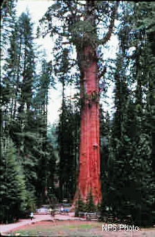
The General Sherman Tree in Sequoia National Park is the largest (by volume) tree in the world.
Computing the volume of a standing tree is the practical equivalent of
calculating the volume of an irregular cone. For purposes of volume comparison,
only the trunk of a giant sequoia is measured, including the restored
volume of basal fire scars. Using these accepted standards and actual
field measurements taken in 1975, the volume of the Sherman Tree was calculated
to be slightly over 52,500 cubic feet (1,486.6 cubic meters).
|
|
|
|
|---|---|---|
| Height above Base | 274.9 | 83.8 |
| Circumference at Ground | 102.6 | 31.1 |
| Maximum Diameter at Base | 36.5 | 11.1 |
| Diameter 60' (18.3 m) above base | 17.5 | 5.3 |
| Diameter 180' (54.9 m) above base | 14.0 | 4.3 |
| Diameter of Largest Branch | 6.8 | 2.1 |
| Height of First Large Branch above the Base | 130.0 | 39.6 |
| Average Crown Spread | 106.5 | 32.5 |
It is difficult to appreciate the size of the giant sequoias because neighboring trees are so large. The largest of the sequoias are as tall as an average 26-story building, and their diameters at the base exceed the width of many city streets. As they continue to grow, they produce about 40 cubic feet of wood each year, approximately equal to the volume of a 50-foot-tall tree one foot in diameter.
The ages of the General Sherman, General Grant and other large sequoias
are unknown, but it is estimated that these giants are between 1800 and
2700 years old. They have seen civilization come and go, survived countless
fires and long periods of drought, and continue to flourish -- inspiring
yet another generation of admirers.
|
TREE |
LOCATION |
HEIGHT (Feet) |
CIRCUMFERENCE (Feet) |
VOLUME (Cubic feet) |
|
|---|---|---|---|---|---|
|
1. |
General Sherman |
Giant Forest |
274.9 |
102.6 |
52,508 |
|
2. |
Washington |
Giant Forest |
254.7 |
101.1 |
47,850 |
|
3. |
General Grant |
Grant Grove |
268.1 |
107.5 |
46,608 |
|
4. |
President |
Giant Forest |
240.9 |
93.0 |
45,148 |
|
5. |
Lincoln |
Giant Forest |
255.8 |
98.3 |
44,471 |
|
6. |
Stagg |
Alder Creek |
243.0 |
109.0 |
42,557 |
|
7. |
Boole |
Converse Basin |
268.8 |
113.0 |
42,472 |
|
8. |
Genesis |
Mountain Home |
253.0 |
85.3 |
41,897 |
|
9. |
(Franklin, near Washington) |
Giant Forest |
223.8 |
94.8 |
41,280 |
|
10. |
(King Arthur) |
Garfield |
270.3 |
104.2 |
40,656 |
|
11. |
(Monroe, near Auto Log) |
Giant Forest |
247.8 |
91.3 |
40,104 |
|
12. |
Robert E. Lee |
Grant Grove |
254.7 |
88.3 |
40,102 |
| 13 |
(J. Adams, near Cattle Cabin) |
Giant Forest |
250.6 |
83.3 |
38,956 |
|
14. |
Ishi Giant |
Kennedy |
248.1 |
105.1 |
38,156 |
|
15. |
(Near Pershing) |
Giant Forest |
243.8 |
93.0 |
37,295 |
|
16. |
(Summit) |
Mountain Home |
244.0 |
82.2 |
36,600 |
|
17. |
(Euclid) |
Mountain Home |
272.7 |
83.4 |
36,122 |
|
18. |
Washington |
Mariposa Grove |
236.0 |
95.7 |
35,901 |
|
19. |
Pershing |
Giant Forest |
246.0 |
91.2 |
35,855 |
|
20. |
(Diamond) |
Atwell |
286.0 |
95.3 |
35,292 |
|
21. |
Adam |
Mountain Home |
247.4 |
94.2 |
35,017 |
|
22. |
(Roosevelt or "False Hart") |
Redwood Mountain |
260.0 |
80.0 |
35,013 |
|
23. |
Nelder |
Nelder |
266.2 |
90.0 |
34,993 |
|
24. |
(AD) |
Atwell |
242.4 |
99.0 |
34,706 |
|
25. |
Hart |
Redwood Mountain |
277.9 |
75.3 |
34,407 |
|
26. |
Grizzly Giant |
Mariposa Grove |
209.0 |
92.5 |
34,005 |
|
27. |
Chief Sequoyah |
Giant Forest |
228.2 |
90.4 |
33,608 |
|
28. |
Methuselah |
Mountain Home |
207.8 |
95.8 |
32,897 |
|
29. |
Great Goshawk |
Freeman Creek |
255.2 |
90.2 |
32,783 |
|
30. |
(Hamilton) |
Giant Forest |
238.5 |
82.6 |
32,783 |
What to Do Kings Canyon National Park?
Campgrounds in Sequoia and Kings Canyon National Parks campgrounds are located in oak woodlands in the warm, dry foothills and in the higher, cooler conifer forests. They range in elevation from 2,100 to 7,500 feet (640 to 2,300 m). Lodgepole, Dorst, Grant Grove and Atwell Mill campgrounds are near giant sequoia groves. In general, higher elevation campgrounds are cooler and closer to giant sequoias.
Visit Crystal Cave
Crystal is the parks' only commercialized cave. It has 3 miles of passage, making it the second longest cave in the two parks. More than 2,000 feet of passage and three new entrances were found in the early 1990s. The cave is a complex, "anastomotic" maze and is heavily decorated with many varieties of speleothems including rarely formed "shields" and "raft cones". The cave has suffered heavy vandalism through its commercialization. Crystal has at least four unique species of invertebrates including spiders and aquatic isopods living in the cave stream.
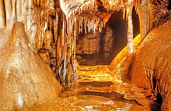
View of the Fairy Pool formation in Crystal Cave in Sequoia
National Park. Tours available May-October.
By some accounts Sequoia and Kings Canyon National Parks could have been set aside solely to protect the amazing caves found in this area of the Southern Sierra Nevada. The two parks protect half of the caves more than a mile long in California, the longest cave in the state, numerous karst streams and some of the best alpine karst topography in the United States. The caves contain Pleistocene era fossils, rare minerals and unique animals. They are the sites of numerous scientific research projects and provide recreational opportunities to thousands of park visitors each year.
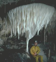
Visitor views a large white shield formation in the ceiling of Hurricane Crawl Cave in Sequoia and Kings Canyon National Parks
Photo by Dick LaForge
A shield formation with many stalactites growing from its underside in the upper levels of Hurricane Crawl Cave.
Efforts to protect and manage this resource are nearly as old as the parks themselves. The parks' first superintendent, Walter Fry, gave detailed descriptions of five of the caves in his 1918 annual report. Crystal Cave has been one of the parks' primary visitor attractions since 1941. In the 1970s, the Cave Research Foundation documented more than 80 caves in Sequoia and Kings Canyon. However, it was the discovery of Hurricane Crawl Cave in 1986 that encouraged the parks to begin an active cave management program. This effort resulted in the employment of a "cave specialist" in 1992 and the completion of a Cave Management Plan in 1994. A revision of the first overall Cave Management Plan was also completed in 1999. Specific management plans have also been created for Soldiers, Crystal and Hurricane Crawl caves. These plans combine management strategies in a single cave. Some passages are open to visitation, some sections have visit restrictions and other passages are completely closed to protect delicate cave features.
In recent years detailed maps of many park caves have also been created. Maps are a key requirement for proper management and research in caves because they document the caves, their features and their extent. Crystal Cave was mapped between 1995 and 1998. From the field work, a series of maps was produced that document the cave's mineralogical features, its exploration history, passage elevations (and thus the history of the cave's development), Crystal's streams and lakes, management restrictions, the cave lighting system, and much more. Other maps of Hurricane Crawl and Soldiers caves have also been completed. Peter Bosted, chief cartographer for the Cave Research Foundation, has coordinated a project to produce more than 80 quadrangle maps of Lilburn Cave. These maps show this very complex cave in detail.
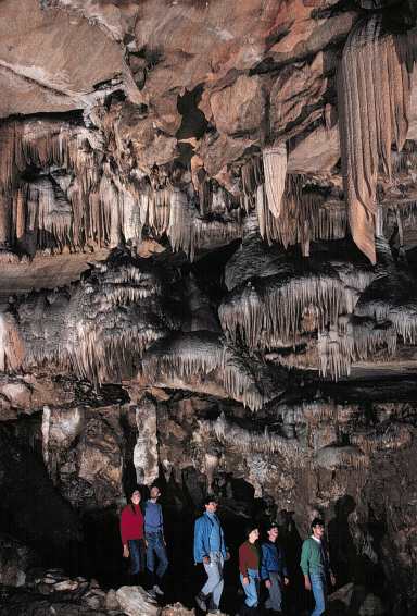
Tourists enjoy the views in Marble Hall, the largest room in Crystal Cave. Crystal Cave was developed for public tours in 1938 and 1939 and has since had well over 1 million visitors.
Another important area of work in park caves is restoration. While restoration in a national park seems surprising, past visitors and employees in the parks have made reversible mistakes that damaged and altered caves. In some cases, caves can restore themselves through natural processes that remove or cover dirt, graffiti, paint and soot. This process is happening right now in Clough and Crystal caves. Crystal Cave has also seen restoration projects that removed tons of blast rubble dumped into the cave during trail construction in the 1930s. Work in the cave has removed damaging lint and dirt from formerly pristine walls. In 1998 a workroom built into the cave was partially restored in the hope that this would provide more habitat for Pimoa spiders that live only near the cave's four entrances. Cave enthusiasts first explored Soldiers Cave in 1949 and 1950. Since then it has remained a popular cave with recreational cavers. Unfortunately the cave combines muddy areas with passages that have beautiful white walls and delicate formations. Through the 50 years that the cave has been open for caving trips, hundreds of square feet of the cave's walls were muddied and damaged. In 1994 and 1995 water from a nearby surface stream was diverted for a few days through hoses that led into the cave's damaged passages. This water was used to clean these surfaces and restore the cave to its original appearance and character.
In general, caves in the two parks are managed by category. Some caves
can be visited by anyone at any time. Other caves, with rare and sensitive
animals or mineralogical features may be closed to entry. A few caves
are set aside for research and study. Some others that are delicate or
dangerous require the presence of an experienced trip leader known as
a "Trustee" before access is allowed. Six park caves are gated,
meaning that the entrances contain locked gates of metal bars that protect
the cave from uninformed trespassers or which protect any trespassers
from dangers in the cave. Most of the 200 caves are small and found in
isolated sections of the parks, far from any roads.
Geography in Canyon National Park
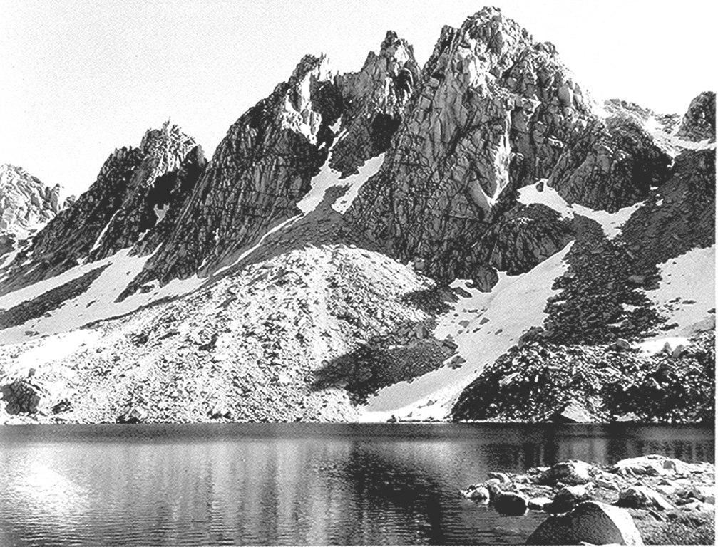
Kearsarge Pinnacles, photo by Ansel Adams
Dusy Basin in Kings Canyon
Kings Canyon National Park consists of two sections. The small, detached General Grant Grove section of Kings Canyon National Park preserves several groves of giant sequoia including the General Grant Grove, with the famous General Grant Tree, and the Redwood Mountain Grove, which is the largest remaining natural Giant Sequoia grove in the world (covering 3,100 acres (1,300 ha) and with 15,800 sequoia trees over one foot (30 cm) in diameter at their bases). The park's Giant Sequoia forests are part of 202,430 acres (81,920 ha) of old-growth forests shared by Sequoia and Kings Canyon National Parks. This section of the park is mostly mixed conifer forest, and is readily accessible via paved highways.
The remainder of Kings Canyon National Park, which comprises over 90% of the total area of the park, is located to the east of General Grant Grove and forms the headwaters of the South and Middle Forks of the Kings River and the South Fork of the San Joaquin River. Both the South and Middle Forks of the Kings Rivers have extensive glacial canyons. One portion of the South Fork canyon, known as the Kings Canyon, gives the entire park its name. Kings Canyon is one of the deepest canyons in the United States. The canyon was carved by glaciers out of granite. The Kings Canyon, and its developed area, Cedar Grove, is the only portion of the main part of the park that is accessible by motor vehicle. Both the Kings Canyon, and its Middle Fork twin, Tehipite Valley, are glacial “Yosemites”–deeply incised glacial gorges with relatively flat floors and towering granite cliffs thousands of feet high. In addition, the canyon has several cave systems, one of which is the Boyden Cave, which is open to the public.
To the east of the canyons are the high peaks of the Sierra Crest culminating in 14,248-foot (4,343 m) high North Palisade, the highest point in the park. This is classic high Sierra country: barren alpine ridges and glacially scoured lake-filled basins. Usually snow free only from late June until late October, the high country is accessible only via foot and horse trails. The Sierran crest forms the eastern boundary of the park, from Mount Goethe in the north, down to Junction Peak, at the boundary with Sequoia National Park. Several passes cross the crest into the park, including Bishop Pass, Taboose Pass, Sawmill Pass, and Kearsarge Pass. All of these passes are above 11,000 feet (3,400 m) elevation.
Natural Features & Ecosystems in Sequoia and Kings Canyon National Park
In Sequoia and Kings Canyon National Parks, the dynamic landscape evolves from geologic processes working over millennia to sculpt granite, marble and other forms of rock. Here in the parks are canyons carved by rivers and glaciers, towering rugged peaks and miles of underground caverns. Found throughout the park are thousands of lakes and ponds and miles of rivers and streams; together they form important watersheds in the park. These watersheds are a valuable source of water not only to park resources but also to the inhabitants of California’s Central Valley.
Here is a detailed list of other National Parks of California besides Kings Canyon National Park.
| National Parks of California | |||||||||||||||||||||||||
|---|---|---|---|---|---|---|---|---|---|---|---|---|---|---|---|---|---|---|---|---|---|---|---|---|---|
|
|||||||||||||||||||||||||
Camping Resources
Free Services
Free Text MessagesFree Picture Messages
Free Fax
Free Calls