National Park in Death Valley, California - Guide to California's Death Valley National Park
Death Valley National Park is a national park in the U.S. states of California and Nevada located east of the Sierra Nevada in the arid Great Basin of the United States. The park protects the northwest corner of the Mojave Desert and contains a diverse desert environment of salt-flats, sand dunes, badlands, valleys, canyons, and mountains. It is the largest national park in the lower 48 states and has been declared an International Biosphere Reserve. Death Valley National Park is visited annually by more than 770,000 visitors who come to see its diverse geologic features, desert wildlife, historic sites, scenery, and clear night skies.
It is the hottest and driest of the national parks in the United States. The second-lowest point in the Western Hemisphere is in Badwater Basin, which is 282 feet (86 m) below sea level. The park is home to many species of plants and animals that have adapted to this harsh desert environment. Some examples include creosote bush, Bighorn Sheep, Coyote, and the Death Valley Pupfish, a survivor of much wetter times. Approximately 95% of the park is designated as wilderness. Its wilderness area covers 4,774 square miles (12,360 km2), making it the largest in the Lower 48 states, and the sixth largest in the United States overall.
A series of Native American groups inhabited the area from as early as 7000 BCE, most recently the Timbisha around 1000 AD who migrated between winter camps in the valleys and summer grounds in the high mountain ridges. The first documented non-Native Americans to enter Death Valley did so in the winter of 1849 looking for a shortcut to the gold fields of California. They were stuck for weeks and in the process gave the valley its name, even though only one of their group actually died there.
Mining was the primary activity in the area before it was protected. Several short-lived boom towns sprang up during the late 19th and early 20th centuries to exploit minor local bonanzas of gold. The only long-term profitable ore to be mined, however, was borax, a mineral used to make soap and an important industrial compound. Today, borax is an essential component of high-temperature resistant boro-silicate glass products, for example Pyrex cookware. Twenty-mule teams were used to transport ore out of the valley; helping to make it famous and the subject of books, radio programs, television series, and movies.
Tourism blossomed in the 1920s, when resorts were built around waters sources at Stovepipe Wells and Furnace Creek. Pacific Coast Borax, a major landowner, and others like Death Valley Scotty promoted the region. Death Valley National Monument was declared a U.S. National Monument in 1933, placing the area under federal protection. In 1994, the monument was redesignated a national park, as well as being substantially expanded to include Saline and Eureka valleys.
The natural environment of the area has been shaped largely by its geology. The valley itself is actually a graben. The oldest rocks are extensively metamorphosed and at least 1.7 billion years old. Ancient warm, shallow seas deposited marine sediments until rifting opened the Pacific Ocean. Additional sedimentation occurred until a subduction zone formed off the coast. This uplifted the region out of the sea and created a line of volcanoes. Later the crust started to pull apart, creating the current Basin and Range landform. Valleys filled with sediment and, during the wet times of glacial periods, with lakes, such as Lake Manly.
The park covers 5,262 square miles (13,630 km2), encompassing Saline Valley, a large part of Panamint Valley, almost all of Death Valley, and parts of several mountain ranges. The bulk of the park is in southern Inyo County and northern San Bernardino County in Eastern California. A small triangular extension near Rhyolite, Nevada of approximately 400 square kilometres (150 sq mi) is part of southwestern Nye County and extreme southern Esmeralda County in Nevada. In addition, there is an exclave (Devil's Hole) in southern Nye County administered by the Park.
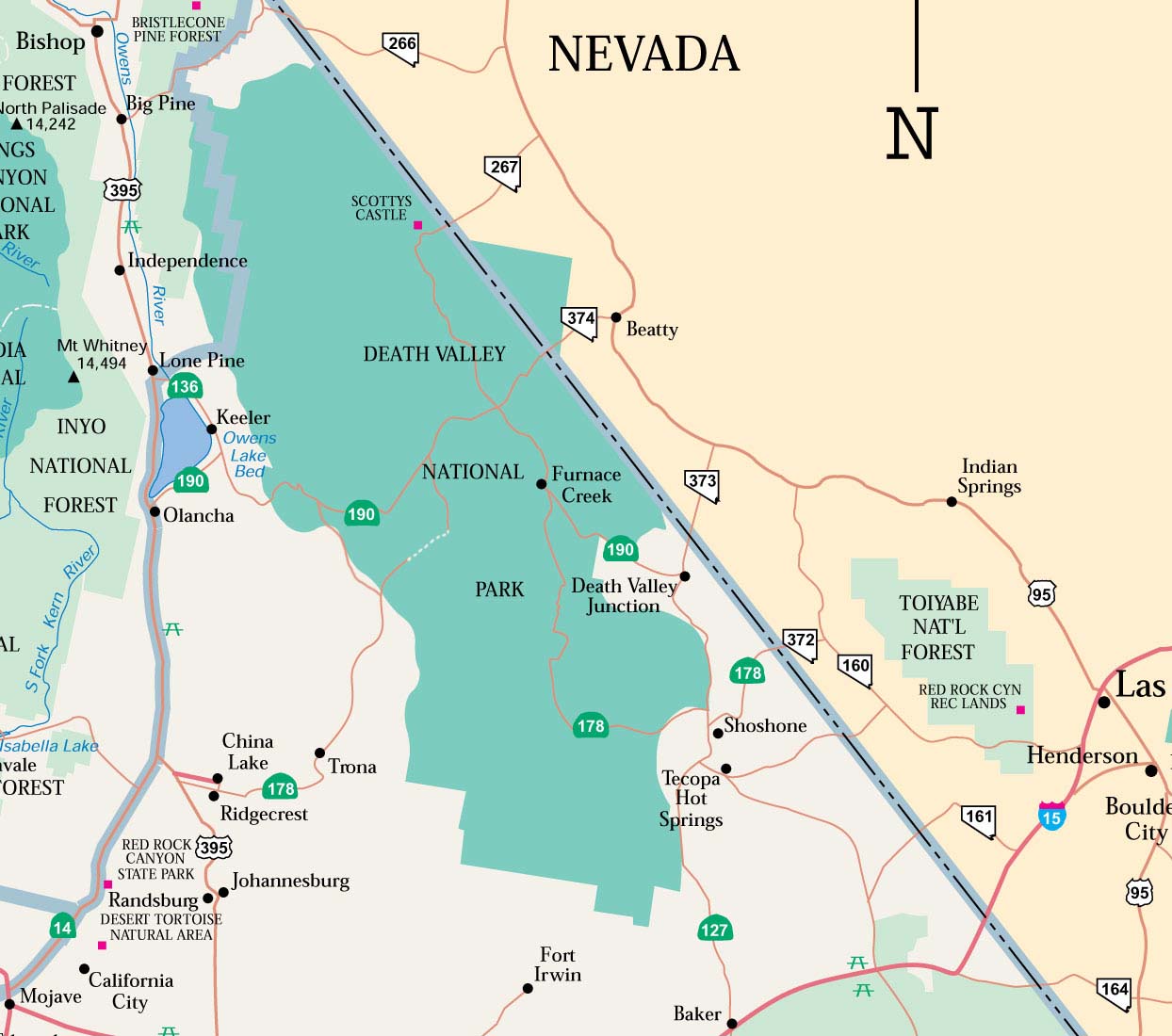
Death Valley National Park Map and Directions
The main road transecting Death Valley National Park from east to west
is California Highway 190.
On the east in Nevada, U.S. Route 95 parallels the park from north to
south with connecting highways at Scotty's Junction (State Route 267),
Beatty (State Route 374), and Lathrop Wells (State Route 373).
Routes From Las Vegas (191kb PDF file)
Coming from the west, State Route 14 and U.S. Route 395 lead to Ridgecrest,
CA where State Route 178 heads east into the park. Further north on Hwy
395 at Olancha, CA you can join Hwy 190 to the park, or north of that
at Lone Pine, CA, Hwy 136 will also join Hwy 190 heading east into the
park.
South of the park, Interstate 15 passes through Baker, California on its
way from Los Angeles to Las Vegas. State Route 127 travels north from
Baker to Shoshone and Death Valley Junction with connections to the park
on State Route 178 from Shoshone and connection with California Highway
190 at Death Valley Junction.
For your GPS use following address: 328 Greenland Blvd, Death Valley,
CA 92328.
Activities in Death Valley National Park
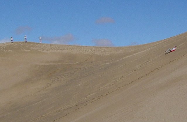
A tourist sliding down Star Dune in the Mesquite Flat Dune field
Enhance your experience of Death Valley by joining a ranger guided tour or program. Explore historic mining sites, shadowy canyons or sun-drenched salt flats. Discover hidden desert wildlife and ephemeral fields of wildflowers. Tours of Scotty's Castle are available year-round, while talks and walks based out of the Furnace Creek Visitor Center are presented from November to April. Additional programs may be presented at other times, ask at the Visitor Center for more information.
Sightseeing is available by personal automobile, four-wheel
drive, bicycle, mountain bike (on established roadways only), and hiking.
Riding through the park on motorcycle is also a popular pastime. State
Route 190, the Badwater Road, the Scotty's Castle Road, and paved roads
to Dante's View and Wildrose provide access to the major scenic viewpoints
and historic points of interest. More than 350 miles (560 km) of unpaved
and four-wheel-drive roads provide access to wilderness hiking, camping,
and historical sites. All vehicles must be licensed and street legal.
There are hiking trails of varying lengths and difficulties, but most
backcountry areas are accessible only by cross-country hiking. There are
literally thousands of hiking possibilities. The normal season for visiting
the park is from October 15 to May 15, because of summer extremes in temperature.
A costumed living history tour of the historic Death Valley Scotty's Castle
is conducted for a fee.
There are nine designated campgrounds within the park, and overnight backcountry camping permits are available at the Visitor Center. Xanterra Parks & Resorts owns and operates a private resort, the Furnace Creek Inn and Ranch Resort, which comprises two separate and distinct hotels: the Furnace Creek Inn is a four-star historic hotel, and the Furnace Creek Ranch is a three-star ranch-style property reminiscent of the mining and prospecting days. Xanterra also operates the Stovepipe Wells Village motel. The Furnace Creek Inn and Ranch and the Stovepipe Wells Village are the only inns located inside Death Valley proper. There are a few motels near various entrances to the park, in Shoshone, Death Valley Junction, Beatty, Nevada, and Panamint Springs.
The visitor center is located in the Furnace Creek resort area on State Route 190. A 12-minute introductory slide program is shown every 30 minutes. During the winter season—November through April—rangers offer interpretive tours and a wide variety of walks, talks, and slide presentations about Death Valley cultural and natural history. The visitor center has displays dealing with the park's geology, climate, wildlife and natural history. There are also specific sections dealing with the human history and pioneer experience. The Death Valley Natural History Association maintains a bookstore specifically geared to the natural and cultural history of the park.
Death Valley National Park is a popular location for stargazing as it has one of the darkest night skies in the United States. Despite Death Valley's remote location, its air quality and night visibility are threatened by civilization. In particular, light pollution is introduced by nearby Las Vegas. The darkest skies are, in general, located in the northwest of the park.
Geography of Death Valley National Park
There are two major valleys in the park, Death Valley and Panamint Valley. Both of these valleys were formed within the last few million years and both are bounded by north–south-trending mountain ranges. These and adjacent valleys follow the general trend of Basin and Range topography with one modification: there are parallel strike-slip faults that perpendicularly bound the central extent of Death Valley. The result of this shearing action is additional extension in the central part of Death Valley which causes a slight widening and more subsidence there.
Uplift of surrounding mountain ranges and subsidence of the valley floor are both occurring. The uplift on the Black Mountains is so fast that the alluvial fans (fan-shaped deposits at the mouth of canyons) there are small and steep compared to the huge alluvial fans coming off the Panamint Range. Fast uplift of a mountain range in an arid environment often does not allow its canyons enough time to cut a classic V-shape all the way down to the stream bed. Instead, a V-shape ends at a slot canyon halfway down, forming a 'wine glass canyon.' Sediment is deposited on a small and steep alluvial fan.
Throughout the western United States, a series of generally north-south running mountain ranges tower over intervening valleys. When the valley has no outlet for water runoff, it is termed a basin. This is the case in many of the interior valleys of the western part of the United States, and had led to the geographical term of "basin and range" for the entire area. When sufficient precipitation over extended periods of time wash small earthern particles into the lowest points in the valley, a flat surface of fine sediment can form. Due to the overwhelmingly arid conditions found here, the water covering this surface is temporal, evaporating quickly. A playa is then left behind, referring to the absolutely flat, usually salt-laden surface that is formed.
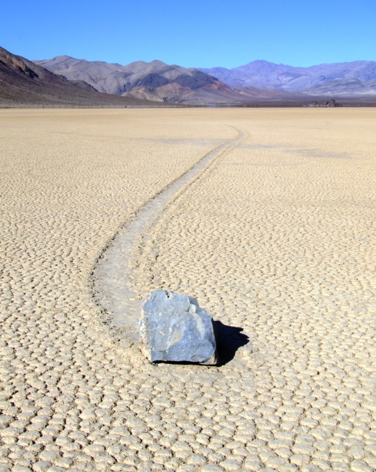
Racetrack Playa, view from south edge of the playa towards The Grandstand
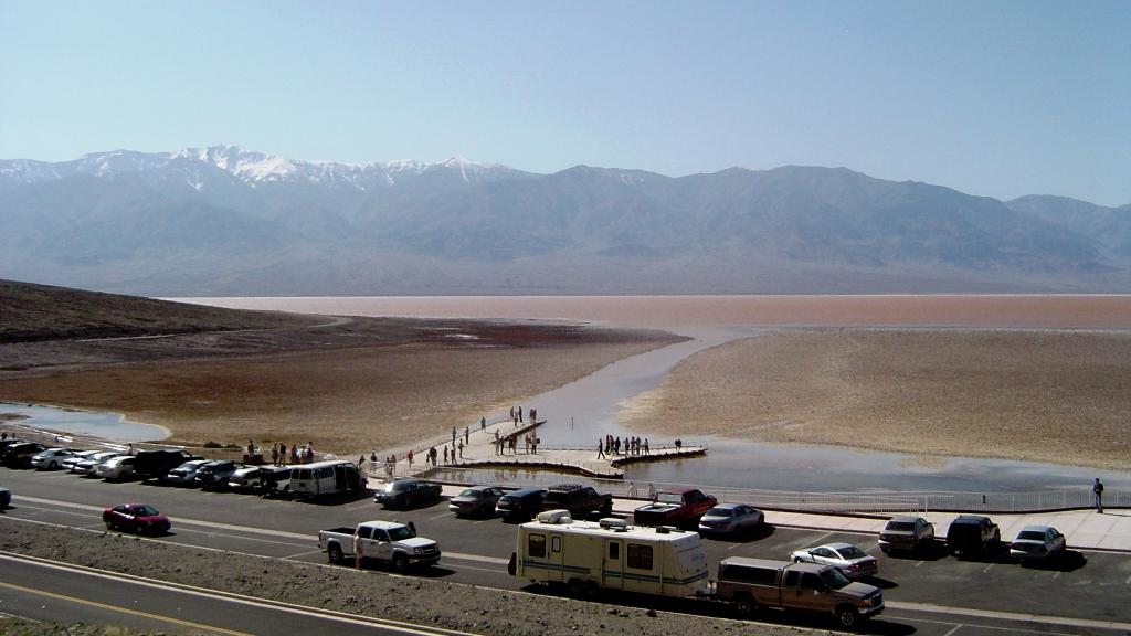
Within Death Valley National Park there are two very distinctive playas. The most accessible is that located at Badwater in the southern part of the park, with a paved road and parking area at its eastern end.
Near the northern end of the park is the much more remote Racetrack Playa. To reach it one travels about 30 miles (48 km) over a gravel road from Ubehebe Crater to Teakettle Junction and down into the Racetrack Playa. While the road is rough in areas, in good weather the Racetrack can be accessed by high-clearance two-wheel-drive vehicles. The road may be temporarily closed to even four-wheel-drive vehicles during or after severe rainfalls.
At 282 feet (86 m) below sea level, Badwater Basin on Death Valley's floor is the second-lowest point in the Western Hemisphere (behind Laguna del Carbón in Argentina), while Mount Whitney, only 85 miles (137 km) to the west, rises to 14,505 feet (4,421 m). This topographic relief is the greatest elevation gradient in the contiguous United States and is the terminus point of the Great Basin's southwestern drainage. Although the extreme lack of water in the Great Basin makes this distinction of little current practical use, it does mean that in wetter times the lake that once filled Death Valley (Lake Manly) was the last stop for water flowing in the region, meaning the water there was saturated in dissolved materials. Thus the salt pans in Death Valley are among the largest in the world and are rich in minerals, such as borax and various salts and hydrates. The largest salt pan in the park extends 40 miles (64 km) from the Ashford Mill Site to the Salt Creek Hills, covering some 200 square miles (520 km2) of the valley floor. The best known playa in the park is the Racetrack, known for its moving rocks.
Climate in Death Valley National Park
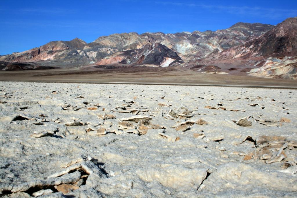
Devil's Golf Course in Death Valley

A slice through the highest and lowest points in Death Valley National Park
Death Valley is the hottest and driest place in North America because of its lack of surface water and its low relief. It is so frequently the hottest spot in the United States that many tabulations of the highest daily temperatures in the country omit Death Valley as a matter of course. On July 10, 1913, a record 134 °F (56.7 °C) was measured at the Weather Bureau's observation station at Greenland Ranch (now the site for the Furnace Creek Inn), the highest temperature ever recorded on that continent as of 2007. Daily summer temperatures of 120 °F (49 °C) or greater are common, as well as below freezing nightly temperatures in the winter. July is the hottest month, with an average high of 115 °F (46 °C) and an average low of 88 °F (31 °C). December is the coldest month, with an average high of 65 °F (18 °C) and an average low of 39 °F (4 °C). The record low is 15 °F (-9.4 °C).
Several of the larger Death Valley springs derive their water from a
regional aquifer, which extends as far east as southern Nevada and Utah.
Much of the water in this aquifer has been there for many thousands of
years, since the Pleistocene ice ages, when the climate was cooler and
wetter. Today's drier climate does not provide enough precipitation to
recharge the aquifer at the rate at which water is being withdrawn.
The highest range within the park is the Panamint Range with Telescope Peak being its highest point at 11,049 feet (3,368 m). The Death Valley region is a transitional zone in the northernmost part of the Mojave Desert and consists of five mountain ranges removed from the Pacific Ocean. Three of these are significant barriers: the Sierra Nevada, the Argus Range, and the Panamint Range. Air masses tend to lose moisture as they are forced up over mountain ranges, in what climatologists call a rainshadow effect.
The exaggerated rainshadow effect for the Death Valley area makes it North America's driest spot, receiving about 1.5 inches (38 mm) of rainfall annually at Badwater (some years fail to register any measurable rainfall). Annual average precipitation varies from 1.92 inches (49 mm) overall below sea level to over 15 inches (380 mm) in the higher mountains that surround the valley. When rain does arrive it often does so in intense storms that cause flash floods which remodel the landscape and sometimes create very shallow ephemeral lakes.
Lake Badwater, spring, 2005
The hot, dry climate makes it difficult for soil to form. Mass wasting, the down-slope movement of loose rock, is therefore the dominant erosive force in mountainous area, resulting in "skeletonized" ranges (mountains with very little soil on them). Sand dunes in the park, while famous, are not nearly as numerous as their fame or the dryness of the area may suggest. One of the main dune fields is near Stovepipe Wells in the north-central part of the valley and is primarily made of quartz sand. Another dune field is just 10 miles (16 km) to the north but is instead mostly composed of travertine sand. Yet another dune field is near the seldom-visited Ibex Hill in the southernmost part of the park, just south of the Saratoga Springs marshland. Prevailing winds in the winter come from the north, and prevailing winds in the summer come from the south. Thus the overall position of the dune fields remains more or less fixed.
There are rare exceptions to the dry nature of the area. In 2005, an unusually wet winter created a 'lake' in the Badwater Basin and led to the greatest wildflower season in the park's history.
Death Valley National Park History
Death Valley was a popular winter destination. Other facilities started off as private getaways but were later opened to the public. Most notable among these was Death Valley Ranch, better known as Scotty's Castle. This large ranch home built in the Spanish Revival style became a hotel in the late 1930s and, largely because of the fame of Death Valley Scotty, a tourist attraction. Death Valley Scotty, whose real name was Walter Scott, was a gold miner who pretended to be owner of "his castle", which he claimed to have built with profits from his gold mine. Neither claim was true, but the real owner, Chicago millionaire Albert Mussey Johnson, encouraged the myth. When asked by reporters what his connection was to Walter Scott's castle, Johnson replied that he was Mr. Scott's banker.
President Herbert Hoover proclaimed a national monument in and around Death Valley on February 11, 1933, setting aside almost two million acres (8,000 km2) of southeastern California and small parts of southwesternmost Nevada. Twelve companies worked in Death Valley using Civilian Conservation Corps workers during the Great Depression and on into the early 1940s. They built barracks, graded 500 miles (800 km) of roads, installed water and telephone lines, and erected a total of 76 buildings. Trails in the Panamint Range were built to points of scenic interest, and an adobe village, laundry and trading post were constructed for Shoshone Indians. Five campgrounds, restrooms, an airplane landing field and picnic facilities were also built.
Creation of the monument resulted in a temporary closing of the lands
to prospecting and mining. However, Death Valley was quickly reopened
to mining by Congressional action in June of the same year. As improvements
in mining technology allowed lower grades of ore to be processed, and
new heavy equipment allowed greater amounts of rock to be moved, mining
in Death Valley changed. Gone were the days of the "single-blanket,
jackass prospector" long associated with the romantic west. Open
pit and strip mines scarred the landscape as international mining corporations
bought claims in highly visible areas of the national monument. The public
outcry that ensued led to greater protection for all national park and
monument areas in the United States.
Inside an abandoned mine at Leadfield
In 1976 Congress passed the Mining in the Parks Act, which closed Death Valley National Monument to the filing of new mining claims, banned open-pit mining and required the National Park Service to examine the validity of tens of thousands of pre-1976 mining claims. Mining was allowed to resume on a limited basis in 1980 with stricter environmental standards. The park's Resources Management Division monitors mining within park boundaries and continues to review the status of 125 unpatented mining claims and 19 patented claim groups, while ensuring that federal guidelines are followed and the park's resources are protected. As of 2003, the only active mining operation in Death Valley National Park is the Billie Mine, an underground borax mine located along the road to Dante's View.
Death Valley National Monument was designated a biosphere reserve in 1984. On October 31, 1994, the Monument was expanded by 1.3 million acres (5,300 km2) and redesignated a national park by passage of the Desert Protection Act. This made it the largest national park in the contiguous United States.
Many of the larger cities and towns within the boundary of the regional ground water flow system that the park and its plants and animals rely upon are experiencing some of the fastest growth rates of any place in the United States. Notable examples within a 100-mile (160 km) radius of Death Valley National Park include Las Vegas and Pahrump, Nevada. In the case of Las Vegas, the local Chamber of Commerce estimates that 6,000 people are moving to the city every month. Between 1985 and 1995, the population of the Las Vegas Valley increased from 550,700 to 1,138,800.
Biology in Death Valley National Park
Habitat varies from saltpan at 282 feet (86 m) below sea level to the sub-alpine conditions found on the summit of Telescope Peak, which rises to 11,049 feet (3,368 m). Vegetation zones include Creosote Bush, Desert Holly, and mesquite at the lower elevations and sage up through shadscale, blackbrush, Joshua Tree, pinyon-juniper, to Limber Pine and Bristlecone Pine woodlands. The saltpan is devoid of vegetation, and the rest of the valley floor and lower slopes have sparse cover, although where water is available, an abundance of vegetation is usually present. These zones and the adjacent desert support a variety of wildlife species, including 51 species of native mammals, 307 species of birds, 36 species of reptiles, 3 species of amphibians, and 2 species of native fish.
Small mammals are more numerous than large mammals, such as Bighorn Sheep, Coyotes (image), Bobcats, Kit Foxes, Cougars, and Mule Deer. Mule Deer are present in the pinyon/juniper associations of the Grapevine, Cottonwood, and Panamint ranges. Bighorn Sheep are a rare species of mountain sheep that exist in isolated bands in the Sierra and in Death Valley. These are highly adaptable animals and can eat almost any plant. They have no known predators, but humans and burros compete for habitat.
The ancestors of the Death Valley Pupfish swam to the area from the Colorado River via a long-since dried-up system of rivers and lakes (see Lake Manly). They now live in two separate populations: one in Salt Creek and another in Cottonball Marsh.
Death Valley is one of the hottest and driest places in North America, yet it is home to over 1,000 species of plants; 23 of which are not found anywhere else. Adaptation to the dry environment is key. For example, creosote bush and mesquite have tap-root systems that can extend 50 feet (15 m) down in order to take advantage of a year-round supply of ground water. The diversity of Death Valley's plant communities results partly from the region's location in a transition zone between the Mojave Desert, the Great Basin Desert and the Sonoran Desert.
This location, combined with the great relief found within the Park,
supports vegetation typical of three biotic life zones: the lower Sonoran,
the Canadian, and the Arctic/Alpine in portions of the Panamint Range.
Based on the Munz and Keck (1968) classifications, seven plant communities
can be categorized within these life zones, each characterized by dominant
vegetation and representative of three vegetation types: scrub, desert
woodland, and coniferous forest. Microhabitats further subdivide some
communities into zones, especially on the valley floor.
Unlike more typical locations across the Mojave Desert, many of the water-dependent Death Valley habitats possess a diversity of plant and animal species that are not found anywhere else in the world. The existence of these species is due largely to a unique geologic history and the process of evolution that has progressed in habitats that have been isolated from one another since the Pleistocene epoch.
Here is a detailed list of other National Parks of California besides Channel Islands National Park.
| National Parks of California | |||||||||||||||||||||||||
|---|---|---|---|---|---|---|---|---|---|---|---|---|---|---|---|---|---|---|---|---|---|---|---|---|---|
|
|||||||||||||||||||||||||
Camping Resources
Free Services
Free Text MessagesFree Picture Messages
Free Fax
Free Calls