Sequoia National Park - Guide to California's Sequoia National Park

Sequoia National Park is a national park in the southern Sierra Nevada, east of Visalia, California, in the United States of America. It was established on September 25, 1890. The park spans 404,051 acres (1,635 km2). Encompassing a vertical relief of nearly 13,000 feet (4,000 m),[1] the park contains among its natural resources the highest point in the contiguous 48 United States, Mount Whitney, at 14,505 feet (4,421 m) above sea level. The park is south of and contiguous with Kings Canyon National Park; the two are administered by the National Park Service together.
The park is famous for its Giant Sequoia trees, including the General Sherman tree, the largest tree on Earth. The General Sherman tree grows in the Giant Forest, which contains five out of the ten largest trees in the world, in terms of wood volume. The Giant Forest is connected by the park's Generals Highway to Kings Canyon National Park's General Grant Grove, home to the General Grant tree among other sequoias. The park's Giant Sequoia forests are part of 202,430 acres (81,921 ha) of old-growth forests shared by Sequoia and Kings Canyon National Parks. Indeed, the parks preserve a landscape that still resembles the southern Sierra Nevada before Euro-American settlement.
Recreation Sequoia National Park
Back country Hiking
The High Sierra Trail passes over the Great Western Divide at Kaweah Gap, climbing some 5,000 ft (1,500 m) in 3 miles (5 km). The valley below it is referred to as Valhalla.
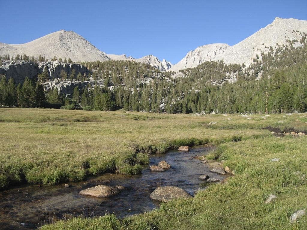
The vast majority of the park is roadless wilderness; in fact, to the surprise of many visitors, no road crosses the Sierra Nevada within the park's boundaries. 84% of Sequoia and Kings Canyon National Parks is designated as Wilderness[6] and is accessible only by foot or by horse.
Sequoia's backcountry offers a vast expanse of high-alpine wonders. Covering
the highest-elevation region of the High Sierra, the backcountry includes
Mount Whitney on the eastern border of the park, accessible from the Giant
Forest via the High Sierra Trail. On a traveler's path along this 35-mile
(56 km) backcountry trail, one passes through about 10 miles (16 km) of
montane forest before reaching the backcountry resort of Bearpaw Meadow,
just short of the Great Western Divide. Bearpaw Meadow offers rustic tent
cabins and gourmet meals cooked by a seasonal resident park crew.
Crabtree Meadows, west of Mt. Whitney.
Continuing along the High Sierra Trail over the Great Western Divide via Kaweah Gap, one passes from the Kaweah River Drainage, with its characteristic V-shaped river valleys, and into the Kern River drainage, where an ancient fault line has aided glaciers in the last ice age to create a U-shaped canyon that is almost perfectly straight for nearly 20 miles (32 km). On the floor of this canyon, at least 2 days hike from the nearest road, is the Kern Canyon hot spring, a popular resting point for weary backpackers. From the floor of Kern Canyon, the trail ascends again over 8,000 ft (2,400 m) to the summit of Mount Whitney.
At Mount Whitney, the High Sierra Trail meets with the John Muir Trail and the epic Pacific Crest Trail, which continue northward along the Sierra crest and into the backcountry of Kings Canyon National Park.
Camping
Campgrounds in the park include three in the foothills area: Potwisha (42 sites), Buckeye Flat (28 sites), and South Fork (10 sites). Four campgrounds are at higher, conifer-dominated elevations, ranging from 6,650 to 7,500 feet (2,000 to 2,300 m): Atwell Mill (21 sites), Cold Springs (40 sites), Lodgepole (214 sites), and Dorst Creek (204 sites).
Other Activities
In addition to hiking, camping, fishing, and backpacking, the following attractions are highlights with many park visitors:
Sherman Tree Trail An 0.8-mile roundtrip paved trail that descends from the parking lot to the base of the General Sherman Tree that meanders through a grove of giant sequoia trees.
Tunnel Log is a tunnel cut through a fallen giant sequoia tree in Sequoia National Park in California. The tree, which measured 275 feet (84 m) tall and 21 feet (6.4 m) in diameter, fell across a park road in 1937 due to natural causes. The following year, a crew cut an 8-foot (2.4 m) tall, 17-foot (5.2 m) wide tunnel through the trunk, making the road passable again.
Crescent Meadow is a small, sequoia-rimmed meadow in the Giant Forest region of Sequoia National Park. This sierran montane meadow marks the western terminus of the High Sierra Trail, which stretches from the meadow across the Great Western Divide to Mount Whitney. Pioneer Hale Tharp homesteaded in this and nearby Log Meadow. Conservationist John Muir visited this meadow many times and praised it highly calling it the "Gem of the Sierras". The meadow lies at the end of a three mile paved road which leaves the Generals Highway near the Giant Forest Museum.
Moro Rock is a granite dome located in the center of the park, at the
head of Moro Creek, between Giant Forest and Crescent Meadow. A 400-step
stairway, built in the 1930s by the Civilian Conservation Corps, is cut
into and poured onto the rock, so that visitors can hike to the top. The
stairway is listed on the National Register of Historic Places. The view
from the rock encompasses much of the Park, including the Great Western
Divide. It has an elevation of 6,725 feet (2,050 m).
Directions and Maps
Use this park headquaters address in a GPS to get driving directions to Sequoia National Park:
220 N Santa Fe St
Visalia, CA 93292-6436
Cave Tutoring in Sequoia National Park
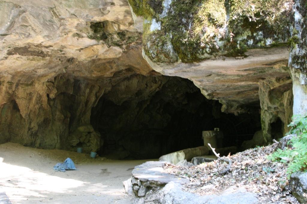
Little known to many visitors, the park is home to over 240 known caves, and potentially hundreds more. The caves in the park include California's longest cave at over 20 miles (32 km), Lilburn Cave, as well as recently discovered caves that remain strictly off-limits to all but a handful of specialists who visit on rare occasions to study cave geology and biology. The only cave open to park visitors remains Crystal Cave, the park's second-longest at over 3.4 miles (5.5 km) and remarkably well-preserved for the volume of visitation it receives annually. It was discovered on April 28, 1918 by Alex Medley and Cassius Webster. The cave is a constant 9 °C (48 °F), and only accessible by guided tour.
Climate in Sequoia National Forest
Weather in RNSP is greatly influenced by the Pacific Ocean. Coastal temperatures generally range between 40 and 60 degrees Fahrenheit (4–15 °C) all year round, while further from the coast summers are hotter and drier, and winters are colder. Redwoods mostly grow a mile or two (1.5–3 km) from the coast, but never more than 50 miles (80 km) from it. In this temperate but humid coastal zone, the trees receive moisture from both heavy winter rains and persistent summer fog. The presence and consistency of the summer fog is actually more important to overall health of the trees than heavy precipitation. This fact is born out in annual precipitation totals, which range between 25 and 122 inches (63 and 310 cm) annually, with healthy redwood forests throughout the areas of less precipitation because excessive needs for water are mitigated by the ever-present summer fog and the cooler temperatures it ensures. Snow is uncommon even on peaks above 1,500 feet (460 m), further exemplifying the mild, temperate nature of this northern latitude.
Here is a detailed list of other National Parks of California besides Sequoia National Park.
| National Parks of California | |||||||||||||||||||||||||
|---|---|---|---|---|---|---|---|---|---|---|---|---|---|---|---|---|---|---|---|---|---|---|---|---|---|
|
|||||||||||||||||||||||||
Camping Resources
Free Services
Free Text MessagesFree Picture Messages
Free Fax
Free Calls