California Camping
California
Camping Sites
National
Parks of California
California
State Parks
State
Parks Camping Fees
State Parks
Day Use Fees
State Parks
WiFi Access
McGrath State Park on the Beach - Guide to McGrath State Beach
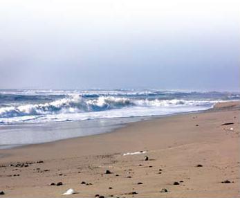
McGrath State Beach in Ventura County (Oxnard, California)
McGrath State Beach is a protected beach park located in the city of Oxnard, California. It is located five miles south of Ventura on Harbor Boulevard.
cGrath State Beach�s lush streamside woodlands, coastal dunes, wide beach and marshlands protect a surprising diversity of plants and animals, including more than 245 bird species. The mouth of the Santa Clara River�one of Southern California�s last undammed rivers�has been designated as the Santa Clara Estuary Natural Preserve, the highest level of protection within the State Park system.
Here is a McGrath State Beach brochure for McGrath State Beach details.
Bird Watching in Oxnard, California
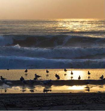
McGrath State Beach Bird Watching in Oxnard
McGrath State Beach is one of the best bird-watching areas in California, with the lush riverbanks of the Santa Clara River and sand dunes along the shore. A nature trail leads to the Santa Clara Estuary Natural Preserve. Two miles of beach provide surfing and fishing opportunities.
McGrath Beach Trail
McGrath State Beach Trail Map in Oxnard, California
From State Beach to McGrath Lake is 4 miles round trip; to Oxnard Shores
is 8 miles round trip; to Channel Islands Harbor is 12 miles round trip.
McGrath State Beach and McGrath Lake were named for the McGrath family
which had extensive coastal land holdings in the Ventura coastal area
dating from 1874. Located on the western city limits of Oxnard, the two
mile long state beach extends south from the Santa Clara River.
A small lake in the southern portion of the park helps to attract more than two hundred species of birds, including black-shouldered kites, northern harriers, owls and herons. Such rare birds as ospreys, white wagtails, black skimmers and peregrine falcons have been sighted here. The lake, which is partially on private property, was damaged by a 1993 oil spill caused by a ruptured pipeline.
The Santa Clara Estuary Natural Preserve on the northern boundary of the park offers a haven for birds and habitat for weasels, skunks, jackrabbits, opossum, squirrels and mice, plus tortoises and gopher snakes.
Near the state beach entry kiosk, a small visitor center features exhibits about the area's plants and wildlife.
This walk takes you on a nature trail through the Santa Clara River Estuary, visits McGrath Lake and travels miles of sandy beach to Channel Islands Harbor.
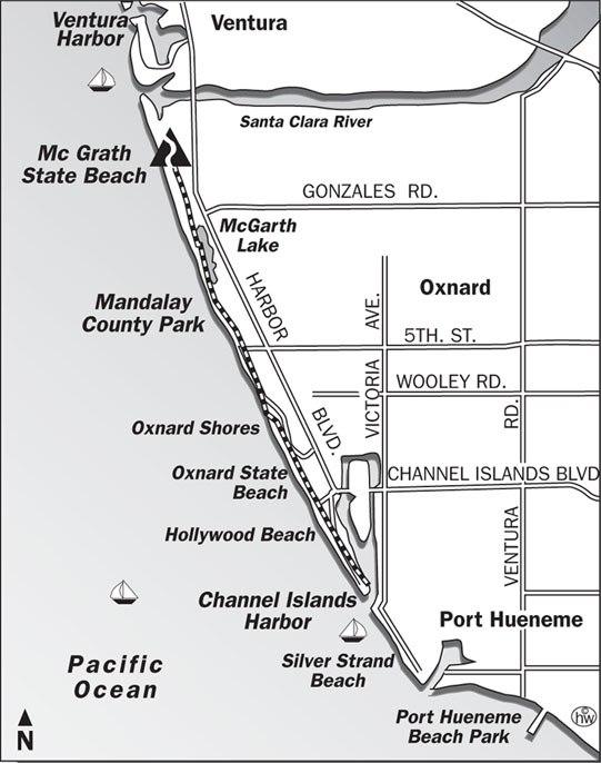
Directions to trailhead: To reach McGrath State Beach, visitors southbound on Highway 101 take the Seaward Avenue offramp to Harbor Boulevard, turn south on Harbor and travel four miles to the park. Northbound visitors exit Highway 101 on Victoria Avenue, turn left at the light to Olivas Park Drive, then right to Harbor Boulevard. Turn left on Harbor and proceed 0.75 mile to the park. The signed nature trail leaves from the day use parking lot. Signposts along the nature trail are keyed to a pamphlet, available at the entry kiosk.
The hike: From the parking lot, follow the nature trail through the estuary. The riverbank is a mass of lush vegetation: willow, silverweed and yerba mansa. In 1980, the Santa Clara River area was declared a natural preserve, primarily to protect the habitat of two endangered birds-the California least tern and Belding's Savannah Sparrow.
When you reach nature trail signpost 11, join a nearby trail that leads atop an old levee, first along the river, then down-coast along the periphery of the state beach campground. This trail joins a dirt road and continues down coast, but the far more aesthetic route is along water's edge, so trudge over the low dunes and walk along the shoreline.
Along the beach, visitors enjoy sunbathing or surf fishing for bass, corbina, or perch. In two miles, if you head inland a short ways, you'll spot McGrath Lake, tucked away behind some dunes.
As you continue south, more sandy beach and dunes follow. You pass a huge, old Edison power plant, and arrive at Oxnard Shores, a development famous for getting clobbered by heavy surf at high tide. The beach is flat and at one time was eroding at the phenomenal rate of ten feet a year. Homes were built right on the shoreline, and many have been heavily damaged. New homes are built on pilings, so the waves crash under rather than through them.
Past Oxnard Shores, a mile of beach walking brings you to historic Hollywood Beach. The Sheik, starring that great silent movie idol Rudolph Valentino, was filmed on the desert-like sands here. Real estate promoters of the time attempted to capitalize on Oxnard Beach's instant fame and renamed it Hollywood Beach. They laid out subdivisions called Hollywood-by-the-Sea and Silver Strand, suggesting to their customers that the area was really a movie colony and might become a future Hollywood, but it never became a mecca for the stars or their fans.
This walk ends another mile down-coast at the entrance to Channel Islands Harbor.
Camping in McGrath State Beach
Camping�The campground has 174 developed sites with picnic tables and fire rings, and restrooms with coin-operated hot showers. A group campsite and a Hikeand- Bike site are also available. Make reservations by calling (800) 444-7275. Reserve the group campsite by calling (805) 648-3918.
Here is a McGrath State Beach camp ground map.
Beach Activities�Beach walkers, sunbathers and surf fishers enjoy McGrath�s 2.5 miles of beach.
Swimming, surfing, and water sports are discouraged because of rip currents.
Adventures in Learning�A mostly barrierfree nature trail extends .2 miles through jungle-like vegetation along the banks of the Santa Clara River. Pick up a free trail guide at the entrance station. Free summer programs interpret the park�s history and habitats.
Recreation Activities in McGrath State Beach
South of McGrath State Beach is the undeveloped Mandalay Beach Park. The beach is located along the California Coastal Trail.
Two miles of beach provide surfing and fishing opportunities, however, swimmers are urged to use caution because of strong currents and riptides. The park offers campsites by the beach.
The beach is adjacent to the Mandalay Generating Station – the stack is easily visible from the beach – and overlies the productive West Montalvo Oil Field. The oil wells in an enclosure just behind the beach are operated by Venoco, Inc., and slant-drill into the offshore part of the field. The generating station is owned by Reliant Energy.
Location of McGrath State Beach
Location: Use following Coordinates: 34°13'30"N 119°15'30"W in a GPS for exact locations. The beach is five miles south of Ventura off Highway 101 via Harbor Boulevard. The official address for McGrath State Beach is 2211 North Harbor Blvd, Oxnard, CA 93035.
McGrath State Beach can be reached at (805) 968-1033.
Nearby State Parks to McGrath State Beach
� San Buenaventura State Beach, in Ventura 3.5 miles north on Harbor
Blvd. to San Pedro Street. (805) 968-1033
� Emma Wood State Beach, in Ventura 9.6 miles north on Highway 101 at
State Beaches exit. (805) 968-1033
� Carpinteria State Beach, in Carpinteria 25.2 miles north on Highway
101 at Casitas Pass Road exit. (805) 968-1033
� Point Mugu State Park, 24 miles south on Highway 1. (818) 880-0363
Here is a detailed list of other state beaches of California besides McGrath State Beach.
| California State Parks on the Beach | ||||
|---|---|---|---|---|
|
||||
Camping Resources
Free Services
Free Text MessagesFree Picture Messages
Free Fax
Free Calls