California Camping
California Camping SitesNational Parks of California
California State Parks
State Parks Camping Fees
State Parks Day Use Fees
State Parks WiFi Access
San Onofre State Parks on the Beach - Guide to San Onofre State Beach
San Onofre State Beach in Oceanside, California (in San Diego County)
San Onofre State Beach is a 3,000-acre (12 km2) state park located in San Diego County, California, USA. The beach is 3 miles (5 km) south of the city of San Clemente on Interstate 5 at Basilone Road. Governor Ronald Reagan established San Onofre State Beach in 1971. With over 2.5 million visitors per year, it is one of the five most-visited state parks in California, hosting swimmers, campers, kayakers, birders, fishermen, off-duty Marines, bicyclists, sunbathers, surfers, and the sacred Native American site of Panhe.
San Onofre State Beach is a rare 3,000-acre scenic coastal-canyon park with high environmental values and recreation use. The park includes three distinct areas: San Onofre Bluffs, San Onofre Surf Beach, and San Mateo Campground.
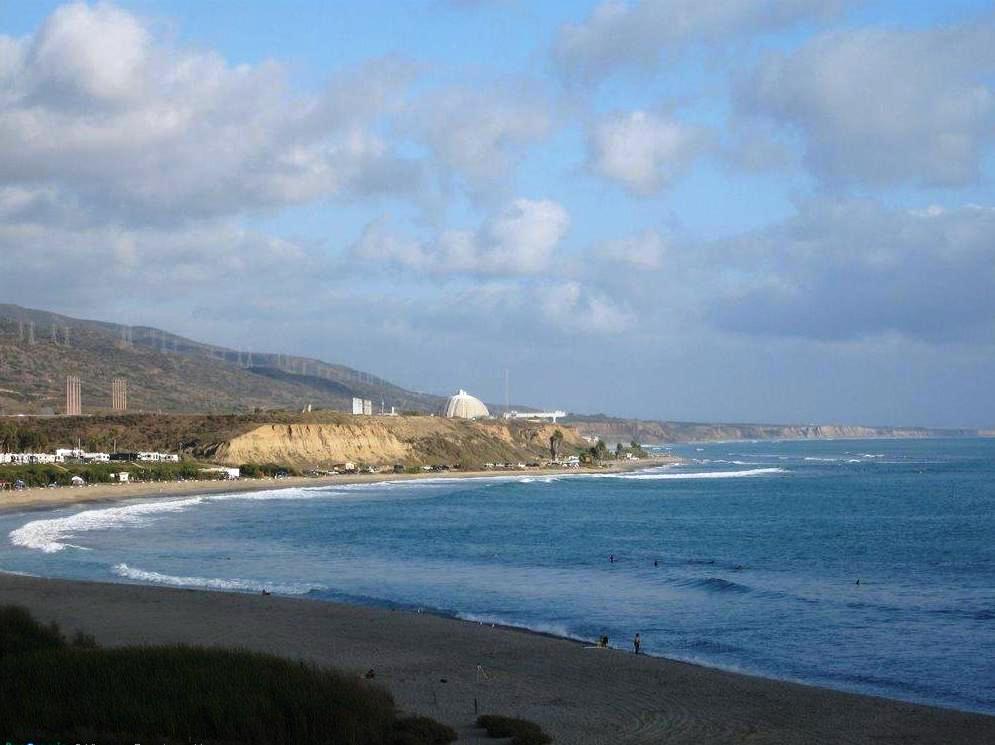
Located between San Onofre Bluffs and San Onofre Surf Beach is the San Onofre Nuclear Generating Station (SONGS), which generates enough energy to power 1.5 million homes in Southern California.
Camping in San Onofre State Beach
San Onofre Bluffs offers camping and day-use parking along Old Highway 101 adjacent to the sandstone bluffs. The beach below is popular with swimmers and surfers with six rugged dirt access trails cut into the bluff above. All campsites include a fire pit and picnic table. The campground offers cold outdoor showers and chemical toilets. No hookups are available however there is a dump-station.
San Onofre's San Mateo Campground lies a short distance inland from the 3.5-miles of sandy beaches within San Onofre State Beach. A 1.5-mile Nature Trail connects the campground to Trestles Beach, a world class surfing site. San Mateo Creek flows just east of the campground outward towards the ocean creating key riparian and wetland habitats which host some rare and even endangered species. All campsites include a fire pit and picnic table. Hookup sites are available with electricity and water. Other amenities includes a dump-station, hot indoor showers, and flush toilets. Camping is available year-round.
Park attractions in San Onofre State Beach
The San Onofre Bluffs portion of San Onofre State Beach features 3.5 miles (5.6 km) of sandy beaches with six access trails cut into the bluff above. The campground is along the old U.S. Route 101 adjacent to the sandstone bluffs. The beach is popular with swimmers and surfers. San Onofre includes San Onofre Bluffs and Beach areas; San Onofre Surf Beach, a day use facility; San Mateo campgrounds and day use facility; and Trestles, accessible via a nature trail from San Mateo Campgrounds. Alcohol is banned from all beaches within the State Park.
The park includes a marshy area where San Mateo Creek meets the shoreline
and Trestles, a well-known California surfing site. Whales, dolphins and
sea lions can be seen offshore from time to time. The park’s coastal
terrace is chaparral-covered.
Surfing in San Onofre State Beach
A surfing and fishing camp had been there since the 1920s, before the land was taken by the U.S. government to establish Camp Pendleton, a U.S. Marine training camp during World War II. Surfers using redwood boards have visited San Onofre since at least the 1940s, including notables Lorrin "Whitey" Harrison, Don Okey, Al Dowden, Tom Wilson, and Bob Simmons.
San Onofre has several surf breaks on its 3.5 miles (5.6 km) of coast, ranging from the beginner’s gentle breaking waves to one of the premiere surf breaks in the United States, Trestles.
Trestles - Trestles is inaccessible by vehicle; a long walk from either
the north or south end is necessary for access. This world-famous surfing
area is known for its consistent waves.
Church - Located near Camp Pendleton’s beach resort, Church provides
sunbathing and duck watching. The name refers to the long-gone chapel
which was located not far from the site.
Surf Beach - The "surf beach" area has 'flush' pit toilets and
cold showers, but no camping. It is divided by the locality into three
breaks spots known as The Point, Old Man’s, and Dogpatch (named from
north to south). All perform best on a south swell, though the beach takes
any surf and slows it down to a very slow pace. The entire area is covered
by a rock reef, often making walking into or out of the water difficult.
Trails - Trails is the most southern of surf spots in this region and
includes both rock bottom and sandy breaks. Trails is also the last point
to camp at San Onofre. Camping is on the bluffs with cold showers and
'flush' pit toilets nearby.
Panhe Tribes Culture
Panhe is an ancient Acjachemen village that is over 8,000 years old and a current sacred, ceremonial, cultural, and burial site for the Acjachemen people. Many Acjachemen people trace their lineage back to Panhe. It is the site of the first baptism in California, and in 1769 saw the first close contact between Spanish explorers, Catholic missionaries, and the Acjachemen people. The United Coalition to Protect Panhe and The City Project advocate for the preservation of the site.
Hiking in San Onofre State Beach: Bluffs Beach Trail
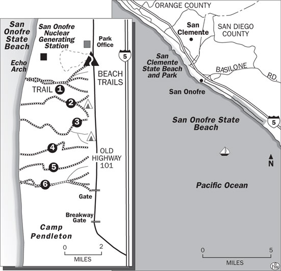
Bluffs Beach Trail map of San Onofre State Beach in Oceanside, California
From Beach Trail 1 to Beach Trail 6 is 5.6 miles round trip.
San Onofre is a place of steep bluffs overlooking a narrow beach with
patches of cobblestone. The beach, named for Egyptian Saint Onuphrius,
is a joy to walk. But be aware that some sections are impassable at the
highest tides. Check the tide table before you hike this beach!
Aptly named Bluffs Beach, part of San Onofre State Beach, is a three mile long sand strand with a backdrop of magnificent, 100-foot high bluffs. The dramatically eroded sandstone cliffs, a kind of Bryce Canyon by the sea, effectively shield the beach from sight and sound of two parallel transportation corridors-the railroad tracks and Interstate 5.
Unfortunately, something of the peaceful ambiance of the park's coastline is diminished by the giant twin spheres of the San Onofre Nuclear Power Plant located just north and Camp Pendleton Marine Base to the south. The nuke and the marines are still very much present, but public access to the splendid beach has loosened up some of late. It's possible to walk a considerable distance both north and south of the power plant.
South of San Onofre State Beach is Camp Pendleton. The camp's beaches are officially off-limits, even if the no trespassing sign is removed, as it often is. However, the prevailing sentiment among beach goers is that the military is considerably less proprietary about its surf and turf these days.
San Onofre State Beach Campground is actually a length of old Coast Highway with some pull-outs. Charmless it is, but it's popular with surfers and other coastal recreationists who rate beach access over amenities.
And the beach access is first rate. A half-dozen signed trails (Beach Trail 1, Beach Trail 2 . . . ) descend from the bluffs to the beach. The paths vary in length from 0.1 to 0.3 mile.
Directions to trailhead: From Interstate 5, a few miles south of San Clemente, exit on Basilone Road. Head west, then south, following the signs to San Onofre State Beach. Park in the first day-use area near the signed trailhead for Beach Trail 1.
The hike: I prefer starting with Beach Trail 1 and walking south along the state beach. From the beaches and bluffs, walkers sometimes spot dolphins, harbor seals and migrating California gray whales.
About three miles of beach-walking brings you to the end of state park property and onto Camp Pendleton's beach. The long sand strand south of the park is popular with nude sunbathers; while it's by no means a legally clothing-optional beach, be advised that many beach-goers opt for none.
Former Nude Beach Area: "Trail 6"
Nudity is prohibited at all parts of San Onofre State Beach, A traditional "clothing optional area" was formerly located at the extreme south end of San Onofre Bluffs beach, loosely accessed via Trail number 6. Since March 2010, park rangers have been citing park visitors for nudity, following the 2009 defeat of a long-running legal challenge by a nudist group.
Location of San Onofre State Beach
The San Onofre State Beach is located at 33°22'45"N 117°34'21"W. The San Onofre State Beach is address is Beach Club Rd, Oceanside, CA 92058.
San Onofre Bluffs and San Onofre Surf Beach are located south of San
Clemente on I-5 (Exit Basilone Road)
San Onofre - San Mateo Campground is located on the outer edge of San
Clemente 1 mile inland from I-5 (Exit Cristianitos).
San Onofre State Beach can be contacted at 949-492-4872.
Here is a driving map to San Onofre State Beach.
Here is a detailed list of other state beaches of California besides San Onofre State Beach.
| California State Parks on the Beach | ||||
|---|---|---|---|---|
|
||||
Camping Resources
Free Services
Free Text MessagesFree Picture Messages
Free Fax
Free Calls